
Rediscovering Ginninderra
These web pages are a portal for 'rediscovering Ginninderra'.
The focus is the century of European settlement from the 1820's to the aftermath of creation of the Capital Territory. Geographically we equate Ginninderra broadly with the catchment of Ginninderra Creek, which aligns well with Lyall Gillespie's observation: "At the time of settlement, Ginninderra district spread from the Murrumbidgee River on its western fringe eastwards beyond Mulligans Flat and from Upper Canberra on its southern boundary northwards to Bedellick on the Yass Road, encompassing the Parishes of Bedulluck, Canberra, Goorooyaroo and Weetangera" (Gillespie, 1992, p.xxi). Click here for an interesting compilation of variations in the spelling of 'Ginninderra'.
We recognise and respect prior indigenous ownership of all the lands of Ginninderra. While there are some references here to indigenous people and culture we have not tried at this time to tell the story of aboriginal habitation and custodianship.
This is a work-in-progress. Entries for some People and Places have not yet been posted, and existing entries can be expanded. Viewers are warmly invited to let us know if you are able to
The display enables you to explore Ginninderra through a selection of prominent Places and People. The database is fully searchable (top right of this page). Zoomable map or satellite imagery enables precise location of Places. People and Places are linked, to each other and to Photos and Documents, where appropriate. References to publications and other web resources accompany entries.
References have been collated into a downloadable Bibliography which will be updated from time to time.
Our work relies heavily on the foundations built by Lyall Gillespie, and particularly his 1992 book 'Ginninderra. Forerunner to Canberra'. Our Centre is now privileged to be custodian of his research collection, and we expect to continue to draw from this well for many years to come.
Your contributions would be welcomed - corrections, additions to existing items, or suggestions about additional People or Places. Our warm thanks to those who have already contributed. Please .
Rediscovering Ginninderra - Location Map
Locate and explore Places which are part of the Ginninderra story - homesteads, schools, churches, places of recreation, and more. Click an icon on the zoomable map, or select from the list of places below it. A number on the map indicates a number of places which are close together.
Hover over an icon to see the name of the place at that location, and click to view the full details and related media. Double-click to zoom in.
Map Legend
Government
- Dog Trap Ford Post Office (1907-1930)
- Ginninderra Police Station
- Ginninderra Post Office
- Jeir Post Office
- Old Weetangera Road
- Walleroo Receiving Office
- Weetangera post office
Community
Education
- Brooklands School
- Ginninderra Public School
- Mulligans Flat School
- Private school of Alfred Rich
- Weetangera Public School
Religious
- Hall cemetery
- Parkwood Chapel
- St Francis Church
- St Ninians Presbyterian Church
- St Paul's Burial Ground
- St Pauls church / school
- Wattle Park church
- Weetengera Church and Cemetery
Recreational
Business
- Ginninderra Blacksmith's Workshop
- Ginninderra Convict Barracks
- Ginninderra Nursery
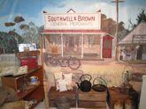
- Ginninderra Store
- Gribbles' Chaff Cutting and Threshing
- Morris' Bootmakers
Homestead
- Allwood
- Ashton
- Belconnen Farm
- Brooklands
- Canberra Park
- Charnwood
- Coppin homestead
- Cranleigh Farm
- Crinigan's Hut (Stone Hut)
- Deasland
- Dellwood
- Dungarvon
- Eastview
- Elm Grove
- Emu Bank
- Eneagh Hill
- Fairview
- Fairy Bower
- Gledeswood
- Glenmoor
- Glenwood
- Gold Creek
- Gungahlin homestead
- Hawthorn Cottage
- Hillside
- Homeleigh
- Horse Park
- Inglewood
- Jeir Station
- Lands End
- Lochleigh
- Malton
- Nine Elms
- One Tree Hill farm
- Palmerville estate
- Parkwood
- Red Hill (Gungaderra) homestead
- Rockwood
- Rosebud Apiary / Rosebud Cottage / Hillview
- Rose Hill
- Rosewood
- Springvale
- Stone Hut farm
- Strathnairn
- Strayleaf
- Sunny Corner
- Sunnyside
- Tea Gardens
- The Falls
- The Glebe
- The Valley
- Wattle Park homestead
- Well(s) Station
- Yerrabi Pond hut
Rediscovering Ginninderra - People
Select from the alphabetical list of People who are part of the Ginninderra story. Those marked with an asterix are 'work in progress'. If you can contribute or have suggestions for additional entries, please .
A
B
- Blewitt , Rosanna Mary
- Blundell, Jacob
- Bolton, Joseph
- Bolton, Mary Ann
- Bolton, Mavis Dawn
- Bondfield, Eric Charles
- Boon, Gladys Elizabeth Clare
- Boon (Senior), David
- Boreham, Edward ('Ted') Alfred
- Bowyer, William
- Boyd, Alexander
- Boyd, William
- Brown, Ebenezer
- Brown, Job
- Brown, Thomas 'Old Tom Brown'
- Brown , Hannah
- Brown (1832 – 1910), Stephen
- Brüning, Joannes ('John') Theodorus Josephus
- Burgoyne, Edward 'Joe'
- Burton, James
- Burton, Sydney ('Sid') William Wells
- Butler, John Albert
- Butler, Nancy (Ann)
- Butler (Junior), John 'Jack'
- Butler (Senior), John
C
- Cameron, Ann
- Cameron, Anne
- Cameron, Edith Lavinia
- Cameron, Ewan
- Cameron Snr, Donald
- Campbell, Charles
- Campbell, Frederick
- Carney, Vera
- Carney, William 'Bill'
- Carpenter, James
- Casey, John
- Cavanagh, Clarence Bede
- Cavanagh, Clarice Esther 'Charl'
- Cavanagh, Ernest MBE
- Cavanagh, Esther Ann
- Cavanagh, Hannah
- Cavanagh, Jane Susan (nee Meade)
- Cavanagh, Mary (nee Logue)
- Cavanagh, Michael Joseph
- Cavanagh, Patrick 'Pat'
- Cavanagh, Thomas
- Clarke, George
- Coates, Richard
- Conlon, Patrick
- Coppin, Catherine
- Coppin, John
- Coulton, Patrick
- Coulton (nee Mills), Sarah
- Crace, Edward Kendall
- Crace, Everard Gregory
- Crace, Helen Blanche
- Crace, John Gregory
- Crace, Kate Marion
- Crinigan, John
- Crinigan, Margaret
- Crinigan, Maria
- Curran, Amy
- Curran, George
- Curran, Henry 'Babe'
- Curran, Henry 'Harry'
D
- Davis, Elizabeth Jane
- Davis, Frederick James
- Davis, Harold Mapletoft
- Davis, Minna Close
- Davis, Samuel
- Davis, Susan Adriana
- Davis (junior), William
- Davis (senior), William
- Dixon, Freda Annie
- Dixon, George Frederick
- Donaldson, Isabella
F
G
- Gallagher, Thomas
- Gasson, Lucy
- Gillespie, George Randleson
- Gillespie, Isabella Hay
- Gillespie, James
- Gillespie, John
- Gillespie, Lyall
- Gillespie, William Ernest
- Ginn, Henry ('Harry')
- Ginn, William
- Gledman, James
- Goslett, John 'Jack' James
- Gozzard, Arthur Vivian*
- Gozzard, Eva Lilian*
- Gozzard (Junior) , Henry Edward
- Gozzard (Senior), Henry
- Grace, James
- Grace, Patrick
- Gribble, Agnes Sandford
- Gribble, Ernest ('Ernie') William
- Gribble, George
- Gribble, Katherine 'Kate'
- Gribble, Thomas 'Tom'
- Gribble, Thomas (senior) Samuel
- Gribble, William Henry
H
- Hall, Henry
- Hall, Mary
- Hamilton, Bobby
- Hamilton, Nellie
- Harcourt, George
- Harcourt, Millicent Sophia
- Hatch, Elizabeth Mary
- Hatch, George Patrick
- Hatch, James Thompson
- Hatch, Margaret Nugent
- Hatch, Mary Ann Jane
- Hatch (junior), William ('Will')
- Hatch (senior), William
- Heaps, Joseph Elias*
- Heley, John
- Hellmund, August Frederick 'Augie'
- Herd, Mary 'Mrs Winter'
- Hibberson, Bridget 'Peggy'
- Hibberson, James Vincent
- Holland, Edward*
- Holland, Henry ('Harry') Edmund
- Holland, Mary Tinham*
- Holligan, Thomas
- Hollingsworth, Malachi
- Hollingsworth, Susan
- Hyland, Thomas
J
- Johnstone, Robert
- Jones, Elsie Leah
- Jones, Florence*
- Jones, Frederick Thomas Tom
- Jones, John
- Jones, Lydia
- Jones, William Henry
- Jones (Snr), Thomas
K
- Keane, John
- Keefe, Margaret*
- Keefe, Michael*
- Keefe, Stephen*
- Kilby, Athol
- Kilby, Beatrice
- Kilby, James Kinloch
- Kilby, Keith
- Kilby, Robert
- Kilby, William
- Kilby [Webster], Jane
- King, William
- Kinlyside, George Kendall
- Kinlyside, James*
- Kinlyside, Thomas
- Kinlyside (Senior), George Kendall
L
M
- Maloney, Margaret 'Maggie'
- Maloney, Mary
- Maloney, Richard
- Maloney, Robert Robin
- Mathieson, Mary
- Mayo, Alfred
- McAuliffe, Flourence
- McAuliffe, Jeremiah
- McAuliffe, Margaret
- McAuliffe, Mary
- McAuliffe, Mary Ann
- McAuliffe (Junior), Thomas
- McAuliffe (Senior), Thomas
- McCarthy, William Ralph
- McCarthy (junior), James
- McCarthy ('Senior'), James*
- McClung, Aubrey William
- McClung (Senior), William
- McDonald, Christina
- McDonald, Donald
- McFarlane, Duncan
- McInnes, Duncan
- McIntosh, Donald*
- McIntosh, James Alexander
- McKeahnie, Archibald
- McKeahnie, Mary
- McLaughlin, James
- McPherson, Hugh 'Ewan'
- Mingo, Ju Nin
- Mohamad, Noor 'Charlie'
- Moon, Ethel Maud
- Moore, Bruce Richard
- Moore, James Courtney
- Moore, Minnie Francis
- Moore , William Lionel
- Moore (Junior), William
- Moore [nee McKenzie], Catherine
- Moore (Senior), William
- Morris, Hannah
- Morris, Henry
- Morris, William 'Billy'
- Mulligan, Edward
- Mulligan, Edward Joseph
- Munday, Ann
- Munday, Frederick
- Munday, James
- Munday, Walter David
- Murphy, Elizabeth*
- Murphy, Henry Maxwell*
- Murty, Donald
- Murty, Frances ('Fanny')
- Murty, Michael
N
O
P
- Palmer, Catherine Irena
- Palmer, Selina Augusta
- Palmer (junior), George Thomas
- Palmer (senior), George Thomas
- Percival, Arthur
- Plummer, Levi
- Plummer, William
- Potter, George
- Preece, Rose
- Preece, Thomas
R
- Read, Ellen
- Read, George
- Read, Hugh
- Read, John
- Reich, Joseph
- Reid, Lilian Anne
- Rich, Alfred Mainwaring
- Rochford, Alexander George
- Rolfe, Ada Mary, Sister Mary de Chantal
- Rolfe, Alice Sister Mary Pierre
- Rolfe, Anthony
- Rolfe, Catherine 'Kitty'
- Rolfe, Catherine*
- Rolfe, Edmund
- Rolfe, James
- Rolfe, Patrick
- Rolfe , Martha
- Rolfe [Keefe], Margaret Jane
- Rule, Agnes
- Rule, David
- Ryan, Edmund 'Ned'
- Ryan, John
- Ryan, Margaret
- Ryan, Michael*
- Ryan, William Old 'Billy'
- Ryan, William
- Ryan, William
S
- Shumack, Alexander ('Alec')
- Shumack, Anne
- Shumack, Edith May
- Shumack, Eliza
- Shumack, Elizabeth Jane
- Shumack, George
- Shumack, John
- Shumack, John (Snr)
- Shumack, Mary Maria
- Shumack, Peter 'Big Pete'
- Shumack, Peter (Senior)
- Shumack, Richard
- Shumack, Samuel
- Shumack (1875-1945), Margaret
- Siggs, Henry
- Singh, Thacker 'Jack'
- Smith, Edward
- Smith, Ellis
- Smith, Jane
- Smith, John
- Smith, Leon Russell
- Smith, Mary
- Smith, Matthias
- Southwell, Eliza Smith [nee Stear]
- Southwell, Eva Annie
- Southwell, George
- Southwell, Horace
- Southwell, James
- Southwell, John
- Southwell, Louisa
- Southwell, Mary (formerly Croxton, nee Roffe)
- Southwell, Richard
- Southwell, Samuel
- Southwell, Samuel*
- Southwell, Thomas
- Southwell , John (b.1818)
- Southwell [1854-1938], Hannah
- Southwell (nee Cooke), Eliza
- Sumner, William
T
- Taylor, Jimmy
- Taylor, Johnny
- Thompson, Charles William
- Thompson, Matilda
- Thornton, Albert Wilde
- Throsby, Charles
- Tickner, John Carpenter
- Tinham, James E
- Tinham, Thomas
V
W
- Walker, John
- Ward, Edmund Miles
- Ward, Margaret
- Warwick, Alexander
- Warwick, Frederick
- Webb, Julia 'Judy the Great'
- Wells, Thomas
- Winter, David
- Winter, John
- Winter, Mary Herd
- Winter, William
- Wyatt, William*